Top Qs
Timeline
Chat
Perspective
Somogy County
County of Hungary From Wikipedia, the free encyclopedia

Remove ads
Somogy (Hungarian: Somogy vármegye, pronounced [ˈʃomoɟ]; Croatian: Šomođska županija; Slovene: Šomodska županija, German: Komitat Schomodei) is an administrative county (comitatus or vármegye) in present Hungary, and also in the former Kingdom of Hungary.


Somogy County lies in south-western Hungary, on the border with Croatia's Koprivnica-Križevci and Virovitica-Podravina counties. It stretches between the river Dráva and the southern shore of Lake Balaton. It shares borders with the Hungarian counties of Zala, Veszprém, Fejér, Tolna, and Baranya. Somogy is the most sparsely populated county in Hungary. The county capital is Kaposvár. Its area is 6,036 km2.
Remove ads
History
Somogy was also the name of a historic administrative county (comitatus) of the Kingdom of Hungary. Its territory, which was slightly larger than that of present Somogy County, is now in south-western Hungary. The capital of that county was also Kaposvár.

Demographics
Summarize
Perspective
Religion in Somogy County (2022 census – of those who declared their religion (62.0%))
- Roman Catholic (63.5%)
- Calvinistic (9.5%)
- Lutheran (2.6%)
- Other Christian denomination (3.8%)
- Other religion (0.5%)
- Not religious (20.1%)
In 2015, it had a population of 312,084 and the population density was 52/km2.
Remove ads
Ethnicity
Besides the Hungarian majority, the main minorities are the Roma (approx. 16,000), Germans (3,000) and Croats (1,500).
Total population (2011 census): 316,137
Ethnic groups (2011 census):[4]
Identified themselves: 287,692 persons:
- Hungarians: 265,464 (92,27%)
- Romani: 16,167 (5,62%)
- Germans: 3,039 (1,06%)
- Others and indefinable: 3,022 (1,05%)
- Approx. 46,000 persons in Somogy County did not declare their ethnic group at the 2011 census.
Religion
Remove ads
Religious adherence in the county according to 2011 census:[5]
- Catholic – 168,307 (Roman Catholic – 167,719; Greek Catholic – 546);
- Reformed – 21,176;
- Evangelical – 5,807;
- other religions – 3,829;
- Non-religious – 35,503;
- Atheism – 3,056;
- Undeclared – 78,459.
Regional structure

| No. | English and Hungarian names |
Area (km2) |
Population (2011) |
Density (pop./km2) |
Seat | No. of municipalities |
| 1 | Barcs District Barcsi járás |
696.47 | 23,793 | 34 | Barcs | 26 |
| 2 | Csurgó District Csurgói járás |
496.19 | 16,862 | 34 | Csurgó | 18 |
| 3 | Fonyód District Fonyódi járás |
645.44 | 33,785 | 52 | Fonyód | 21 |
| 4 | Kaposvár District Kaposvári járás |
1,591.36 | 118,496 | 74 | Kaposvár | 78 |
| 5 | Marcali District Marcali járás |
904.24 | 34,472 | 38 | Marcali | 37 |
| 6 | Nagyatád District Nagyatádi járás |
647.07 | 26,003 | 40 | Nagyatád | 18 |
| 7 | Siófok District Siófoki járás |
657.05 | 51,099 | 78 | Siófok | 24 |
| 8 | Tab District Tabi járás |
427.24 | 12,797 | 30 | Tab | 24 |
| Somogy County | 6,065.07 | 312,084 | 52 | Kaposvár | 245 | |
|---|---|---|---|---|---|---|
Politics
Summarize
Perspective

The Somogy County Council, elected at the 2019 local government elections, is made up of 15 counselors, with the following party composition:[6]
Presidents of the General Assembly
Municipalities
Summarize
Perspective
Somogy County has 1 urban county, 15 towns, 2 large villages and 227 villages.
- City with county rights
(ordered by population, as of 2011 census)
- Kaposvár (66,245) – county seat
- Towns
- Siófok (25,045)
- Marcali (11,736)
- Barcs (11,420)
- Nagyatád (11,032)
- Balatonboglár (5,736)
- Balatonlelle (5,217)
- Csurgó (5,214)
- Fonyód (4,793)
- Tab (4,533)
- Nagybajom (3,330)
- Lengyeltóti (3,050)
- Kadarkút (2,653)
- Zamárdi (2,386)
- Balatonföldvár (2,207)
- Igal (1,270)
- Villages
- Alsóbogát
- Andocs
- Ádánd
- Babócsa
- Bábonymegyer
- Bakháza
- Balatonberény
- Balatonendréd
- Balatonfenyves
- Balatonkeresztúr
- Balatonmáriafürdő
- Balatonőszöd
- Balatonszabadi
- Balatonszárszó

- Balatonszemes
- Balatonszentgyörgy
- Balatonújlak
- Bárdudvarnok
- Baté
- Bálványos
- Bedegkér
- Bélavár
- Beleg
- Berzence
- Bodrog
- Bolhás
- Bolhó
- Bonnya
- Böhönye
- Bőszénfa
- Buzsák
- Büssü
- Csákány
- Cserénfa
- Csokonyavisonta
- Csoma
- Csömend
- Csököly
- Csombárd
- Csurgónagymarton
- Darány
- Drávagárdony
- Drávatamási
- Ecseny
- Edde
- Felsőmocsolád
- Fiad
- Fonó
- Főnyed
- Gadács
- Gadány
- Gamás
- Gálosfa
- Gige
- Gölle
- Gyékényes
- Görgeteg
- Gyugy
- Hajmás
- Hács
- Háromfa
- Hedrehely
- Hencse
- Heresznye
- Hetes
- Hollád
- Homokszentgyörgy
- Hosszúvíz
- Iharos
- Iharosberény
- Inke
- Istvándi
- Jákó
- Juta
- Kapoly
- Kaposfő
- Kaposgyarmat
- Kaposhomok
- Kaposkeresztúr
- Kaposmérő
- Kaposszerdahely
- Kaposújlak
- Karád
- Kastélyosdombó
- Kaszó
- Kazsok
- Kálmáncsa
- Kánya
- Kára
- Kelevíz
- Kercseliget
- Kereki
- Kéthely
- Kisasszond
- Kisbajom
- Kisberény
- Kisbárapáti
- Kisgyalán
- Kiskorpád
- Komlósd
- Kötcse
- Kőröshegy
- Kőkút
- Kutas
- Lábod
- Lad
- Lakócsa
- Látrány
- Libickozma
- Lulla
- Magyaratád
- Magyaregres
- Mernye
- Mesztegnyő
- Mezőcsokonya
- Mike
- Miklósi
- Mosdós
- Nagyberki
- Nagyberény
- Nagycsepely
- Nagykorpád
- Nagyszakácsi
- Nágocs
- Nemesdéd
- Nemeskisfalud
- Nemesvid
- Nikla
- Nyim
- Orci
- Ordacsehi
- Osztopán
- Öreglak
- Ötvöskónyi
- Őrtilos
- Pamuk
- Patalom
- Patca
- Patosfa
- Pálmajor
- Péterhida
- Pogányszentpéter
- Polány
- Porrog
- Porrogszentkirály
- Porrogszentpál
- Potony
- Pusztakovácsi
- Pusztaszemes
- Ráksi
- Rinyabesenyő
- Rinyakovácsi
- Rinyaszentkirály
- Rinyaújlak
- Rinyaújnép
- Ságvár
- Sántos
- Sávoly
- Segesd
- Sérsekszőlős
- Siójut
- Som
- Somodor
- Somogyacsa
- Somogyaracs
- Somogyaszaló
- Somogybabod
- Somogybükkösd
- Somogycsicsó
- Somogydöröcske
- Somogyegres
- Somogyfajsz
- Somogygeszti
- Somogyjád
- Somogymeggyes
- Somogysimonyi
- Somogyszentpál
- Somogyszil
- Somogyszob
- Somogysámson
- Somogysárd
- Somogytúr
- Somogyudvarhely
- Somogyvámos
- Somogyvár
- Somogyzsitfa
- Szabadi
- Szabás
- Szántód
- Szegerdő
- Szenna
- Szenta
- Szentbalázs
- Szentborbás
- Szentgáloskér
- Szenyér
- Szilvásszentmárton
- Szorosad
- Szólád
- Szőkedencs
- Szőlősgyörök
- Szulok
- Tapsony
- Tarany
- Taszár
- Táska
- Tengőd
- Teleki
- Tikos
- Torvaj
- Tótújfalu
- Törökkoppány
- Újvárfalva
- Várda
- Varászló
- Vése
- Visnye
- Visz
- Vízvár
- Vörs
- Zala
- Zákány
- Zics
- Zimány
- Zselickisfalud
- Zselickislak
- Zselicszentpál
![]() municipalities are large villages.
municipalities are large villages.
See also
Gallery
 Kaposvár, the capital of the county
 Siófok, the Capital of Balaton
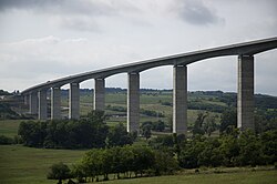 Kőröshegy Viaduct in Kőröshegy
 House of József Rippl-Rónai
 Traditional Hungarian house in Istvándi
 Pusztatemplom of the Árpád era near Somogyvámos


International relations
Somogy County has a partnership relationship with:
|
References
External links
Wikiwand - on
Seamless Wikipedia browsing. On steroids.
Remove ads